
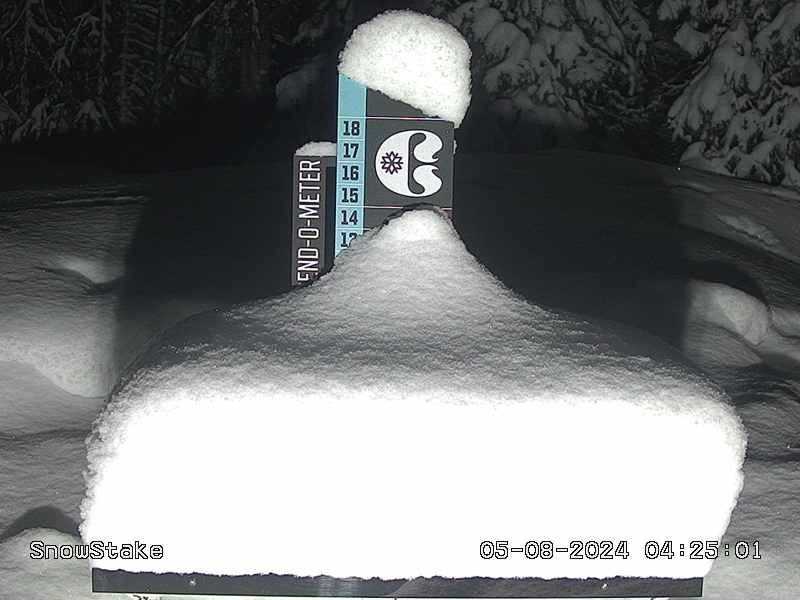
Alta Ski Area, Utah, is in the middle of a storm cycle that’s deposited several feet of snow so far.
To document the storm cycle’s impact, Alta deployed photojournalist Chloe Jimenez. Her assignment? Show the people just how deep it’s gotten.
Unsurprisingly, Jimenez delivered.
View this post on Instagram
It’s a cliche, I know, but in this case, it’s true: a picture—or a few of them—is worth a thousand words. You can stare at forecasts and snowfall totals all day, but without a visual reference, those numbers don’t mean too much.
Jimenez’s photos convey the message more succinctly. Alta got dumped on, and more is on the way.
Alta’s forecast calls for additional snowfall this week, with totals likely reaching above the one-foot mark by Saturday.
February and March have treated the Utah ski area well after a slow start to the season. Both produced frequent snowfall and powder days, with this February being Alta’s third snowiest on record.
This week, Alta surpassed a significant milestone, officially hitting its seasonal average snowfall mark of 546 inches. While that might sound like no big deal, it’s important to remember that the resort wasn’t exactly raking in snow until 2024 rolled around. A lot of ground has been covered since the start of February.
And, as previously noted, it appears even more ground will get covered this week, if you know what I mean.
Related: Entire Mountain West Forecasted To Score Fresh Snow
Don’t miss another headline from POWDER! Subscribe to our newsletter and stay connected with the latest happenings in the world of skiing.
We’re always on the lookout for amusing, interesting and engaging ski-related videos to feature on our channels. Whether you’re a professional or just an amateur, we want to see your best footage and help you share it with the world. Submit your video for a chance to be featured on POWDER and our social channels. Be sure to subscribe to our YouTube channel to watch high-quality ski videos.


